Thursday, November 29, 2012

Is the Tide Turning for the Law of the Sea Convention? Conservatives push for U.S. accession by year's end..

Regular readers of this blog are familiar with the arguments for U.S. accession to the Law of the Sea Convention (simply look to the upper right corner of this page for a partial listing of support).  They are likely also familiar with the misinformation that opponents have spread about the Convention.  A conservative think tank, the Institute for Liberty, has done its own research and changed its mind, arguing forcefully for U.S. accession before the end of 2012.  The institute launched an initiative in August 2012 to promote accession and yesterday its President, Andrew Langer,published a lengthy piece in Real Clear Politics debunking the opposition myths.

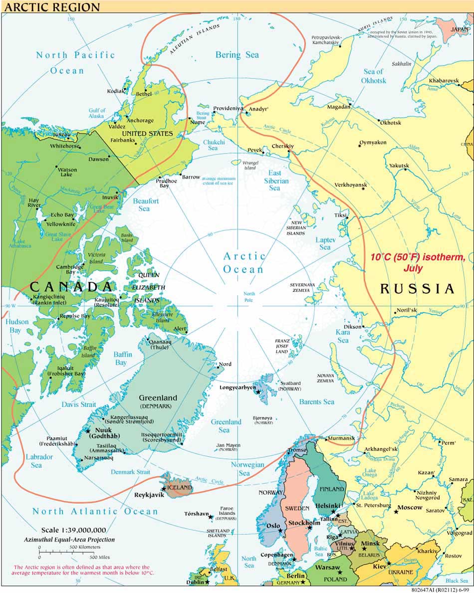
Regular readers also know this blogger's mantra that cooperation, not conflict, rules the day in the Arctic (for a recent piece to that effect see OGEL's special 2012 issue on the Arctic).  While Langer sees a "new Cold War" in the Arctic, he overlooks the fact that Russia is following the same rules and procedures to delineate the extent of its shelf that the Convention prescribes for all states. Notwithstanding this blogger's disagreement on that point, the article is worth a full read, especially for its point-by-point responses to the "disinformation" spread by the Convention's opponents.  Thanks to Caitlyn Antrim for drawing attention to the piece, which is excerpted below from   http://www.realclearpolitics.com/articles/2012/11/28/the_case_for_ratification_of_the_law_of_the_sea_treaty_116272-full.html

"The Case for Ratification of the Law of the Sea Treaty" [EXCERPTS]
By Andrew Langer  - November 28, 2012
"The Stakes Have Rarely Been Higher
"The Institute for Liberty (IFL) has come to the conclusion that ratifying the Law of the Sea Treaty is the most important property rights and wealth building step that America can take to maintain our leading superpower status and to exponentially grow our economy.
There has been a tremendous amount of disinformation about this treaty. In fact, just earlier this year, IFL thought we knew the truth about what was termed “LOST” and we signed a letter opposing ratification. We, like so many other conservatives, were given bad information.
In light of the facts, IFL dropped our opposition to the treaty and we are now leading the conservative charge for its ratification. I am meeting everyday with conservative grassroots leaders to ask them to join me in this imperative course correction and we are making a great deal of progress."

Another short excerpt gives a taste of how the piece debunks false arguments against the Law of the Sea Convention:

[Langer continues:]


"Myth: Ronald Reagan wouldn’t ratify this treaty.
Fact: Ronald Reagan’s Chief of Staff James Baker III supports the treaty’s ratification and he says that this version of the Law of the Sea Treaty is the version that Reagan fought for himself. Baker says that Reagan fought for the mineral rights contained in the treaty and that the mineral rights section is where Reagan’s objects rested – Reagan did not see “backdoor tax” or “sovereignty” boogiemen in LOTS or in the ISA. Hear from Baker yourself. In this video you can watch him talk directly about Ronald Reagan and Law of the Sea Treaty during his remarks of August 26, 2012 (between the time marker 35:29 – 36:32)
Myth: This treaty is an environmentalist ploy.
Fact: False. This treaty is backed by the US military; by the mining, oil and gas industries; by manufacturers; by the defense industry; and, by every living Republican Secretary of State and by every Republican president – essentially, this treaty is backed by everyone the environmentalist community loathes, sues and pickets. The supporters of this treaty are amongst the most vocal critics of so-called “global warming” and have fought the Kyoto Protocol tooth and nail. This treaty is about trillions of dollars of US wealth creation, hundreds of thousands of American jobs, and about the national security benefits that arise from the 100% veto power the U.S. gains over all other nations via ratification.
Myth: U.S. companies can explore mineral claims without ratifying the treaty and joining the ISA.
Fact: False. This is the issue of property rights, which is of tantamount importance in forging political stability and global prosperity. Right now, U.S. business’ mineral claims are imperiled because of our inability to participate in the International Seabed Authority. If other nations can lay claim to these regions, and have the lawful backing of the treaty and the ISA, then our businesses can legally be forced off these claims. U.S. businesses cannot subject themselves to a potential taking scenario where once that have developed a resource, it is taken by China or Russia."

For the full article, go to Real Clear Politics.


Saturday, September 8, 2012

Summer 2012 US Extended Continental Shelf Arctic Mapping

The US Extended Continental Shelf (ECS) mapping project continues in the Arctic Ocean this summer. The USCGC Healy 1202 got underway from Barrow on August 26 with the ECS science crew on board.

Larry Mayer, Director of the Center for Coastal and Ocean Mapping/Joint Hydrographic Center, University of New Hampshire/NOAA, is leading the cruise with Capt. Andy Armstrong, who is blogging about the cruise here.

Browsing the hourly images from the ship's Aloftcon camera is one way to track the remarkable absence of sea ice at various latitudes. Armstrong's blog entry for September 6  says it is shocking to see "entirely open water" at 81 degrees north, but not surprising given the regular ice reports on which they are relying.

The National Snow and Ice Data Center Arctic Sea Ice News provides frequent updates on the record Arctic sea ice minimum reached this summer.  The record minimum set in 2007 was, coincidentally, reached the day Healy 1202 got underway; it has continued to drop throughout September.    As NSIDC reports today, the sea ice

"is now below 4.00 million square kilometers (1.54 million square miles). Compared to September conditions in the 1980s and 1990s, this represents a 45% reduction in the area of the Arctic covered by sea ice. At least one more week likely remains in the melt season."

Captain Armstrong's blog entries for August 31 and September 5 share remarkable images from  previously undiscovered seafloor features west of the Nautilus Basin.

The cruise is expected to wrap up the last week in September.

Friday, May 11, 2012

American Arctic highlighted as key reason for U.S. to join the Law of the Sea Convention

A diverse, bipartisan coalition of politicians, military leaders, corporate interests and environmental groups  has launched a new initiative, The American Sovereignty Campaign, to urge US accession to the UN Convention on the Law of the Sea in the current Congress. The site provides multiple fact sheets, an interactive map and background on why each of the coalition groups supports the Convention. For example, representatives of Lockheed Martin Corporation, Level 3 Communications, the U.S. Chamber of Commerce and the American Petroleum Institute – "made the business case for Law of the Sea Treaty ratification" at a recent Forum sponsored by the Atlantic Council and the Pew Charitable Trusts.


The United States is the only Arctic State that is not a party to the LOS Convention, having first submitted the treaty to the U.S. Senate for approval in 1994, but has not yet acceded to it. Denmark and Canada joined the treaty in 2004 and 2003 respectively. Until the US accedes to the treaty it cannot submit its data regarding the extent of the US extended continental shelf (ECS) to the Commission on the Limits of the Continental Shelf, established under the treaty. Without a Commission recommendation regarding such data, the legal foundation for US ECS limits is much less certain than if the US were a party to the LOS Convention.

The ASC website also addresses arguments, many of them unfounded,  raised by treaty opponents. For example, the site sets straight the record showing that former President Reagan's initial objections to the convention have been resolved.


Wednesday, April 18, 2012

Two Year Anniversary of Deepwater Horizon: Oil Spill Commission Action (US) issues "Report Card"

After concluding their work as the National Commission on the BP Deepwater Horizon Oil Spill and Offshore Drilling, its now former members launched the Oil Spill Commission Action project (OSCA).

In time for the two year anniversary of the Deepwater Horizon disaster (April 20, 2010), OSCA has issued a report card assessing how the US Congress, the Administration and Industry have done in implementing the Commission's Recommendations, which were published in the Commission's Final Report of January 2011. The report explains the summary grades assigned to each actor for its work to date (Congress "D",  Administration "B" and Industry a "B") as follows:

"Overall, we conclude that, although much more needs to be done, the Administration and industry are undertaking important enhancements to make offshore drilling safer and to improve the nation’s ability to respond to oil spills that may occur. Unfortunately, so far, Congress has provided neither leadership nor support for these efforts."

The report assesses five categories, The Arctic among them:
"Safety and Environmental Protection(B)
Industry and most federal agencies have made or are making significant improvements in the way offshore oil operations are developed, carried out, and overseen. These hold promise but continued improvements are required, and Congress has done nothing to make permanent the improvements that have been made.
Spill Response and Containment(B-)
Industry and most federal agencies are also making significant improvements in their ability to contain and respond to offshore oil spills. The nation is certainly in a much better situation than it was two years ago. However, the efficacy of these modifications under the harsh conditions of deep water drilling still needs to be demonstrated and, again, Congress has provided little support for these efforts.
Impacts and Restoration(C)
Implementing the Commission’s recommendations on impacts and restoration is, at best, a work in progress. Though we are hopeful that the current efforts to initiate a comprehensive restoration program in the Gulf will succeed, we are discouraged by the modest steps that have been taken.
Ensuring Adequate Resources(D)
Although the Administration and Congress have provided increases in funding for the Department of the Interior to operate its regulatory programs, Congress has taken no action to make the program self-funding. Nor has Congress taken action to adjust the existing unrealistic limits on liability and response funding.
Frontier Areas—The Arctic (C)
Although there has been some progress in implementing the Commission’s recommendations concerning frontier areas, we feel strongly that additional work must be done to understand the ecosystems of the Arctic and to establish the infrastructure necessary to protect this vulnerable and valuable region."


The OSCA report is available on the group's Website: Oil Spill Commission Action.
Download the report...

Among the many other US resources related to the Deepwater Horizon are reports and data available from NOAA,  from the Department of the Interior (and its Bureau of Safety and Environmental Enforcement and  Bureau of Ocean Energy Management's Deepwater Reading Room); and the Environmental Protection Agency.

Industry, NGOs and media are also marking the second anniversary of the Deepwater Horizon.

Notable among the coverage is American Petroleum Institute Upstream Director, Erik Milito, discussing seven lessons to be learned from the tragedy.  The API is a key player in the Center for Offshore Safety.  The Center was established in partial keeping with a Deepwater Commission's recommendation but, as a fully industry supported center, varies from the recommended independent status of such an organization.
Separately, Alex Chadwick is featured in a broadcast documentary Burn, about the search for oil.
Other media coverage includes:
http://www.emagazine.com/daily-news/bp-spill-two-years-after/;
and


The National Energy Board of Canada completed its post-Deepwater Arctic Ocean Drilling Review, issuing its report in December 2011.

Tuesday, April 17, 2012

NOAA National Geophysical Data Center: new viewer for seafloor and continental shelf data

A new viewer allows anyone with access to the internet to view high-resolution bathymetric and other data depicting information about the world's oceans, seafloor and continental shelves.  The US National Oceanic and Atmospheric Administration (NOAA) makes the information available through its Marine Geology and Geophysics Division in Boulder, Colorado, part of NOAA’s National Geophysical Data Center (NGDC).

An independent report on the new viewer observes that "NGDC’s sea floor data have long been free and open to the public in original science formatting, but that often required the use of specialized software to convert the data into maps and other products. "For serious scientists, the new viewer allows an important preview capability that will help speed data access and analysis. But its real power is exposing a new audience to NOAA data," said Dan Price, bathymetric program manager at NGDC."

The maps can be viewed in Mercator and Arctic Projection and are available here.


Tuesday, February 21, 2012

Two New Map Tools from UNEP Grid/Arendal: Marine-related scientific datasets and Extended Continental Shelf Submissions (geophysical metadata)


The January 2012 Newsletter of UNEP GRID/Arendal's Marine Division features two excellent resources, OCEANIDS and OSDS Data Inventory Map (the featured Map of the Month).


The first, OCEANIDS, is “a new tool to find and examine public marine-related scientific datasets. A main aim in the development of OCEANIDS is to provide end users with an interdisciplinary and multi-thematic geospatial and metadata portal of public data and information – but with the non-GIS expert end user in mind.” For more on how this is accomplished with Geocommons solutions, see the newsletter.


The second resource, the One Stop Data Shop (OSDS) Data Inventory Map “shows all the cruise track lines and point databases that have been collected during the lifespan of the Continental Shelf Programme, and constitutes the world’s largest collection of geophysical metadata relevant for working on delineation of extended continental shelves (ECS) beyond 200 nautical miles.” The map includes “URLs leading to the actual data holder's web pages for that object. Furthermore, the map shows the status of all ECS Submissions received by the Commission on the Limits of the Continental Shelf.  In January 2012 Tanzania was the 59th submission.

As the newsletter announces, the ECS inventory map “is also available for Google Earth as separate layers.”

Icebreaking into the Arctic

The USCGC HEALY embarked Barrow, Alaska, in August 2008 to map the US extended continental shelf, or ECS, in the Arctic Ocean (HLY 0805). Healy sailed again from 7 August to 16 September, 2009 (HLY 0905) to continue ECS mapping, joining with the Canadian icebreaker, the Louis S. St.-Laurent. The two vessels mapped together again in 2010 (see HLY1002) and 2011 (HLY1102).

As the only law professor on the science crew, I was along on HLY 0805 and 0905 to better understand
the science behind the legal process that the UN Convention on the Law of the Sea establishes for states making ECS submissions. As to why the US is mapping now, even though it has not yet acceded to the Convention, read on both here, and in the Law of the Sea notes below.

Thanks to
Vermont Law School and especially to Larry Mayer, Director of the University of New Hampshire's Center for Coastal and Ocean Mapping, for making my part in the trip possible.
Thanks, as well, to Adriane Colburn, for opening new windows on and for the deep.