Wednesday, December 7, 2011

U.S. State Department unveils website on the Law of the Sea Convention

The U.S. Department of State recently launched a new website designed to educate readers about the UN Convention on the Law of the Sea and promote benefits of accession to the treaty. Partly in anticipation of the treaty's consideration in the Senate Foreign Relations Committee (as of yet unscheduled), the State Department's Bureau of Oceans and International Environmental and Scientific Affairs issued several fact sheets in July 2011 that are now available on the website.  The overview fact sheet characterizes the Convention as "a key piece of unfinished treaty business for the United States;" the others address business and national security reasons to support accession to the Convention.

The entries at the bottom of this Arctic Mapping blog provide general information about the history of non-accession to the Convention in the United States; those in the upper right hand margin track more recent developments and expressions of support for accession. 

Tuesday, September 27, 2011

Arctic Regional Hydrographic Commission Meeting, 27-29 September 2011

The Arctic Regional Hydrographic Commission (ARHC) was established a year ago in October 2010, and is currently holding its second meeting in Copenhagen (27-29 September 2011).   Documents submitted for this meeting, including national reports from all five coastal states and a status report (ArHC2-11A) on plans for an Arctic Spatial Data Infrastructure  (Arctic SDI) are available on the ARHC meeting website.  The ARCH held its first meeting in Ottawa (4-6 October 2010). At the first meeting, the report of the US Coastal Hydrographic Commission (USCHC Update)ARHC1-04B indicated that technical experts met in Ottawa on July 22, 2010 in anticipation of a maritime boundary agreement in the Beaufort Sea (see media reports and earlier posts from February 2010 and March 2010 on the progress toward resolution of this maritime boundary dispute).  Technical discussions continue in anticipation of resolving this well-managed maritime boundary disagreement between Canada and the United States.


Tuesday, September 13, 2011

R/V Marcus G. Langseth underway for Chukchi Edges Project

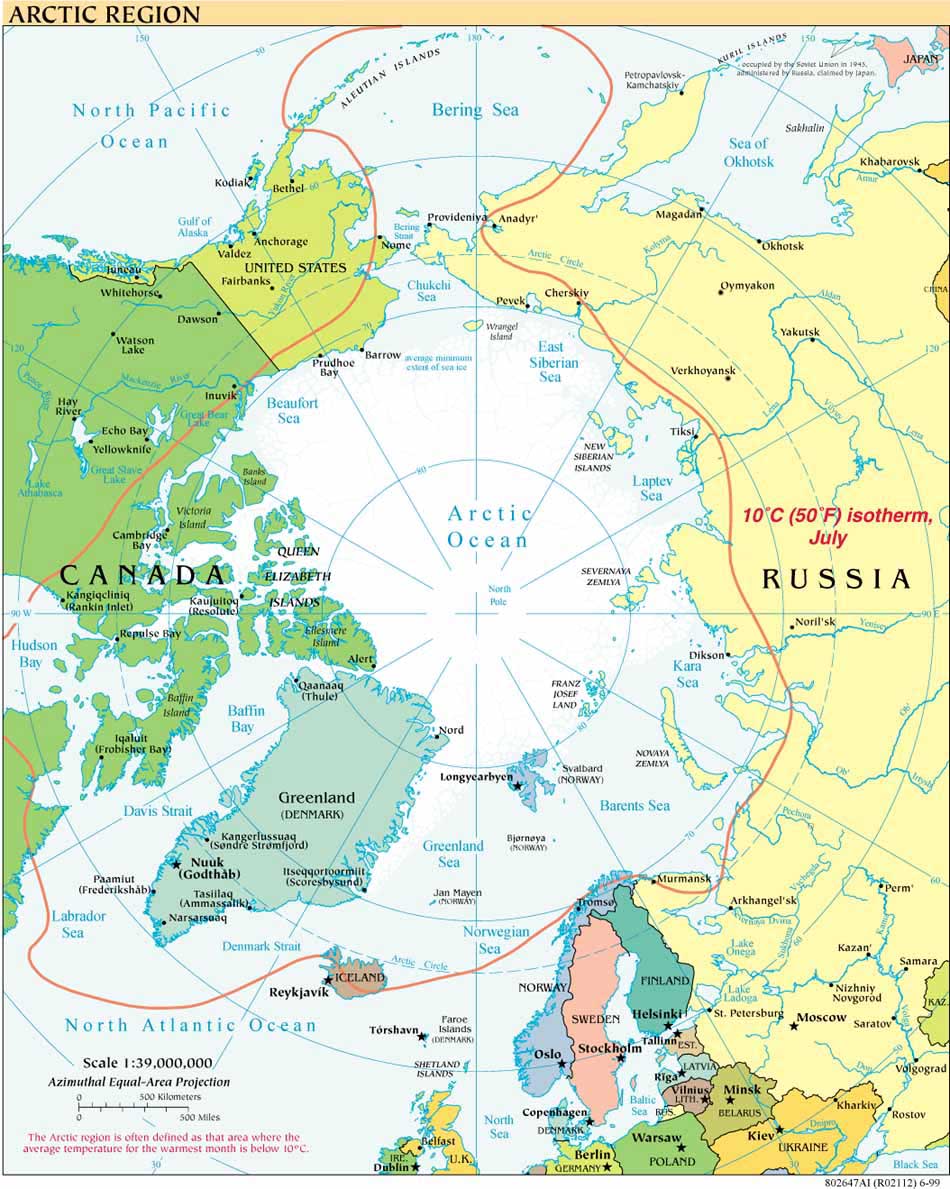
As is clear from following the links to the right of this blog post, the USCGC Healy has been in the Arctic Ocean for several weeks on its “Law of the Sea Extended Continental Shelf” mapping cruise.  This is the fifth year that Healy is working jointly with the Canadian Coast Guard icebreaker Louis S. St. Laurent, collecting data to inform the eventual submission of reports to the Commission on the Limits of the Continental Shelf.

The Research Vessel (R/V) Marcus G. Langseth embarked September 8, 2011, from Dutch Harbor, Alaska, on a different kind of arctic mapping cruise.

As explained on the Langseth Chukchi Edges Project website, “The primary purpose of this cruise is to collect Multi-Channel Seismic Reflection (MCS) data across the transition from the Chukchi Shelf to the Chukchi Borderland.”  One purpose the data will serve is to provide imaging of the transition between these two continental blocks, thus helping to narrow down when and over how long a period the two blocks were in relative motion with each other.  That information is key to understanding the geological history of the area.

As the project's chief scientist, Dr. Bernard Coakley from University of Alaska-Fairbanks, explains:

“The geological history of the Amerasian Basin is poorly understood, in part due to the lack of identified plate boundaries. These boundaries must exist to explain the basin history. Identification of these structures will make it possible to reconstruct the development of the basin, which will substantially improve our understanding of the surrounding continents.”

R/V Langseth is operated by Lamont Doherty Earth Observatory (LDEO) at Columbia University.  The Langseth is not an ice-strengthened vessel and this is the first time it has been used in the Arctic open water season (for more on the expected ice environment for the cruise, see the cruise website.  LDEO has an office devoted to Marine Mammal Protection and Dr. Coakley has worked closely with NOAA to obtain the necessary permits for MCS activity. Community Observer Reynold (RJ) Aveoganna is part of the international team working with Coakley, which includes scientists from Korea, Germany, Turkey, the United States and the United Kingdom, representing seven different universities and research organizations.

The Langseth is scheduled to return to Dutch Harbor on October 10, 2011. Coakley will be blogging for the New York Times Scientist at Work feature throughout the cruise, beginning with today's post under Notes from the Field; subsequent posts will be available here.


Thursday, September 8, 2011

Guyana files submission with the CLCS

On 6 September 2011 Guyana filed the 57th submission to the Commission on the Limits of the Continental Shelf (all 57 submissions are identified on the CLCS website).

The Executive Summary of the submission, available here, indicates that Guyana submits "data and information concerning the outer limits of the continental shelf along the northern part of its continental margin for the consideration of the CLCS without prejudice to any potential boundary delimitations with any other States which may be conducted at a later date."*

Thus, any potential boundary delimitation with Guyana's neighbor to the north, Venezuela, will not be prejudiced by the submission or any eventual Commission recommendation (Venezuela is not a party to the Law of the Sea Convention).  Whether or not the neighboring state is a party to the Convention, such provisions are standard in submissions to the CLCS when the submitting state has unresolved boundaries or potential boundary issues with neighboring states. The Law of the Sea Convention (art. 76, para. 10, and Annex II, art. 9) makes clear that the Commission's role is not to address any such boundary issues, but rather only to consider the data regarding the extent of the continental shelf without prejudice to such issues.
From Guyana's Executive Summary, p. 16: "Figure 1. The outer limits of the continental shelf of the Co-operative Republic of Guyana (red line) beyond 200 nautical miles (black line) measured from the baselines from which the breadth of the territorial sea is measured according to paragraph 7 determined by straight lines not exceeding 60 nautical miles in length, connecting fixed points, defined by coordinates of latitude and longitude."
Consideration of Guyana's submission will be part of the Commission's provisional agenda for the 29th session of the CLCS, scheduled to meet in New York in March/April 2012.  The last submission to the Commission was by Madagascar in April 2011.

*emphasis not in original

UPDATE October 1, 2011: Guyana and Venezuela sign agreement pledging to "negotiate the delimitation of maritime boundaries between the two States."

Wednesday, August 31, 2011

The Arctic, Irene and ... Vermont Law School?

Many readers know that your blogger teaches at Vermont Law School (see blogger profile). Many in the eastern United States also know that Vermont was hard hit by flooding following Hurricane Irene and many have inquired as to how we fared.  Thanks for your concern, and for other readers' indulgence in this non-Arctic report.
Vermont Law School, in South Royalton, Vermont, reopened on August 31, but transportation around the state, and to and from campus, changes daily as roads are reopened, or repaired ... or erode further.  The school suffered only minor flooding but our neighbors in Royalton, South Royalton, Bethel, and numerous small communities have lost homes, livestock, possessions.  For more on the aftermath in Vermont go to vpr.net or onearth.org; and at VLS to irene.vermontlaw.edu or our Facebook or Twitter pages.
We continue our research at the Vermont Institute for Energy and Environment on the PAME Arctic Offshore Oil and Gas Guidelines in Greenland and Russia, and in Canada and the United States (your comments welcome as we update these papers, reply here), on the legal status of sea ice, and on our contribution to the Arctic Ocean Review, among other Arctic-related projects.

Thanks for your concern.

Tuesday, August 30, 2011

Speaking of Icebreakers ... what about Antarctica? NSF contracts with Russian icebreaker.

This blog has written of icebreakers on several occasions (e.g. January 2009 and June 2010), but has focused largely on U.S. and Canadian ice breaking needs in the Arctic.  In early August, the U.S. National Science Foundation announced that the Swedish  government would not be deploying its escort icebreaker Oden south to Antarctica in 2011, as has been the practice in recent years.  The Oden, one of seven icebreakers operated by the Swedish Maritime Administration, is thus not available either for joint research with other countries in the Southern Ocean, or for the annual breakout of the channel that allows the resupply of certain research stations in Antarctica (McMurdo Station, South Pole Station and field camps in the interior of the Antarctic continent).
 
In mid-August, U.S. Senators Maria Cantwell (Washington) and Mark Begich (Alaska) pointed to the practice of contracting with foreign governments for Antarctic ice breaking services when speaking against plans to decommission the Polar Sea, one of the United States' three aging icebreakers.  As Senator Cantwell's press release states "Decommissioning Polar Sea would leave the U.S. with only one operational icebreaker, the Healy, which was designed primarily as a scientific research vessel and only has medium icebreaking capability. The second heavy duty icebreaker, Polar Star, is currently in Seattle being refitted after years in ‘caretaker’ status, when the vessel is out of active service but still receives routine upkeep and maintenance. The United States Navy has no icebreaking capability."

On August 25, 2011, the NSF issued a letter announcing that the "NSF has entered into a letter contract for the services of the Vladimir Ignatyuk, a diesel-powered Russian icebreaker owned by the Murmansk Shipping Company. This ship is the sister to Canada's Terry Fox."

The good news is that Antarctic science stations will continue to be resupplied through international cooperation.  The bad news, which should make its way to the highest level of policy making in the United States, is that our ice breaking capacity is woefully inadequate: inadequate for scientific research North and South, and inadequate for emergency response to oil spills and other potential problems arising from increased exploitation of petroleum resources in the Arctic and from increased marine traffic in the North generally.

Friday, August 5, 2011

International Maritime Organization MEPC agrees on work plan for Black Carbon impacts in Arctic

At the 62nd session of the Marine Environment Protection Committtee, London 11-15 July 2011, the MEPC:
    "agreed a work plan on addressing the impact in the Arctic of black carbon emissions from ships and instructed the Sub-Committee on Bulk Liquids and Gases (BLG) to:  develop a definition for black carbon  emissions from international shipping; consider measurement methods for black carbon  and identify the most appropriate method for measuring black carbon emissions from international shipping; investigate appropriate control measures to reduce the impacts of black carbon emissions from international shipping in the Arctic; and submit a final report to MEPC 65 (in 2014).
     Black carbon is a strongly light-absorbing carbonaceous aerosol produced by incomplete combustion of fuel oil and is considered a constituent of primary particulate matter, as distinguished from secondary particulate matter pollutants formed in the atmosphere from sulphur dioxide emissions. In addition to harmful human health effects associated with exposure to particulate matter, Black carbon has effects on climate change. When deposited on snow and ice in the Arctic and lower latitudes, it darkens light surfaces and absorbs energy, causing snow and ice to melt."

Wednesday, July 13, 2011

Foreign Minister Sergei Lavrov: Law of the Sea Convention, not military involvement, is the basis for activity in the Arctic

In an exclusive interview with Voice of Russia on July 13, Sergei Lavrov, the Minster of Foreign Affairs for the Russian Federation, reiterated that the law of the sea convention is the basis for maintaining security in the Arctic.  He made clear that there is no problem in the Arctic requiring military involvement and emphasized the importance of the law of the sea convention as the foundation for international cooperation in the Arctic.

Lavrov took the opportunity presented by a question on Russia's plans for a new submission to the Commission on the Continental Shelf in 2012 to make his point:

"Interviewer:  You know, it`s been mentioned that Moscow will submit a claim next year to the UN to expand its Arctic shelf borders. Other nations including the US have also increased their activities in the region, and it is described by some analysts as a new re-division of the Arctic. How do you see the role of Russia in this process and does it need to increase its military presence there as the US and Canada do?   May the future of the Arctic be resolved peacefully?

Lavrov:  Well, first of there is no such thing as redesigning of the Arctic landscape and redesigning the legal regime of the Arctic. The five coastal states, the Arctic Five so to say, back in 2008 agreed during their meeting that there is no single problem in the region that cannot be resolved on the basis of existing law, this law being the international Convention of 1982.
Then this position was endorsed by the entire Arctic Council which is composed by eight Arctic states and you now the fact that this is really the case was demonstrated by the signature and entry into force of the Russian-Norwegian agreement on de-limitation in the Barents Sea area.
There is no single issue in the area that would require any military presence of the non-regional actors, be it countries or organizations. The Arctic Five, Russia, the US, Canada, Norway and Denmark are perfectly capable of maintaining the necessary level of security, the freedom of shipping and safety of the shipping and we are open to other countries who want to cooperate but on the basis of the rules of the game established by the Arctic countries.
We met last May in Greenland, in the city of Nuuk, as the Arctic Council ministerial meeting and we adopted the first pan-Arctic legally binding agreement on search and rescue and instructed our experts to draft a Treaty on how you fight oil spills. We also endorsed the rules for observers who want to participate in the work of the Arctic Council which provide for them to be parties to projects like exploration of oil and gas, transportation of oil, gas and other commodities through the Northern Sea route, participation in scientific research and many other activities.
But I would like to emphasize once again that there’s no problem requiring any military involvement in the Arctic. Everything must be and should be on the basis of the international convention of the law of the sea and it’s a common position of the members of the Arctic Council, including Russia and the US." (Emphasis added.)

The Russian research vessel the Akademik Fedorov embarked earlier this month for another summer of mapping related to the the Russian continental shelf submission.

For a digital recording of Voice of Russia's entire interview with Foreign Minister Lavrov, and its full text, see the Voice of Russia report for July 13, 2011.

Charting the US Arctic

Two years ago, in May 2009, the Arctic Council PAME (Protection of the Arctic Marine Environment) Working Group issued  the Arctic Marine Shipping Assessment.  AMSA, a wide-ranging study and must-read for anyone interested in the increasing human uses of the Arctic Ocean, also highlights the inadequacy of navigational charts for various parts of the Arctic Ocean.

This week NOAA's Office of Coast Survey embarked on a charting cruise that is part of a broad-scale NOAA effort to update its charts of the Arctic Ocean, some of which date to before the United States' 1867 acquisition of Alaska.  For more on the work of the NOAA Ship Fairweather visit the NOAA home page under news. The story contains a link to the "Arctic Nautical Charting Plan - A Plan to Support Sustainable Marine Transportation in Alaska and the Arctic" issued by the NOAA Office of Coast Survey Marine Chart Division on June 1, 2011.

Saturday, June 18, 2011

Certainty, not Conflict: The Meeting of the States Parties to the Law of the Sea Convention and the Workload of the Commission on the Limits of the Continental Shelf (CLCS)

At the 21st annual Meeting of States Parties to the Law of Sea Convention (SPLOS) this past week in New York, the workload of the Commission on the Limits of the Continental Shelf was on the agenda.  Perhaps the most important observation on the work of the CLCS came from the Australian representative, who spoke of the value of "creating legal and jurisdictional certainty, in perpetuity, regarding the limits of a country’s continental shelf" (see full text of the Meetings Coverage here).  

Legal and jurisdictional certainty is the expected outcome of every submission to the CLCS, whether  the Arctic or any other part of the world.  Legal and jurisdictional certainty, not conflict, is another message with which to respond to the misinformed or misleading publicists, scholars and practitioners who continue to raise (incorrectly) the alarum that states in the Arctic are locked in some sort of competition or race for resources as they map their extended continental shelves. They are not.  Arctic Ocean coastal states are all, as I've stated before, following the same dry rules and procedures precisely so they can confirm with certainty the extent and limits of the continental shelf and, thus, the areas in which they have sovereign rights to explore and exploit the shelf's natural resources.

The CLCS has received 56 submissions as of April 29, 2011, the last three being from Denmark/Faroes, Bangladesh and Madascar, yet has adopted only 15 recommendations as of March 30, 2011.  The Commission has also received preliminary information for 45 different shelf areas, adding to its backlog. The SPLOS meeting in New York allowed representatives to discuss varying scenarios for improving the Commission's ability to handle the large case load.  The Acting Chairperson of the CLCS is Harald Brekke of Norway.

Tuesday, April 19, 2011

BP Macondo/Deepwater Horizon One Year Later - Implications for the Arctic Ocean

April 20, 2011: The one-year anniversary of the BP Deepwater Horizon explosion and oil spill in the Gulf of Mexico is as weighty a reason as any for breaking the hiatus of several months on this site.  The DWH disaster not only led to formal reviews of arctic offshore drilling practices in the United States  and in Canada  (which had already begun such a review process);  it also prompted widespread discussion of best offshore practices in other arctic coastal states, and contributed to the convening of an Inuit Leaders Summit on Resource Development

The final report of the U.S. National Commission on the BP Deepwater Horizon Oil Spill and Offshore Drilling includes specific reference to implications of the DWH disaster for the Arctic. The Recommendations as well as portions of Chapter Ten in the final report discuss “The Arctic ecosystem, the need for scientific information and informed decision-making, and Alaska native peoples,”  “Arctic Spill Response and Containment,” and “International Standards for Arctic Oil and Gas”.  On the last point,  “the Commission recommends that strong international standards related to Arctic oil and gas activities be established among all the countries of the Arctic.” Recommendations, p. 56.  The Commission staff also prepared a background paper on The Challenges of Oil Spill Response in the Arctic.

Moving in the direction of stronger international standards, the US Secretary of the Interior, Ken Salazar, held a Ministerial Forum on Offshore Drilling Containment  last week (April 14, 2011) to discuss international standards for well containment.  Canada, Norway, The Russian Federation, and the United States -- that is to say: all arctic coastal states save Denmark/Greenland, were there. Angola, Australia, Brazil, Netherlands, New Zealand Mexico, the EU, and the United Kingdom, also attended.

Secretary Salazar will also attend the May ministerial meeting of the Arctic Council with Secretary of State Clinton, where offshore oil and gas development is on the agenda. In 2009 the Arctic Council ministers endorsed “Arctic Offshore Oil and Gas Guidelines” prepared by its PAME (Protection of the Marine Environment) working group.  The Institute for Energy and the Environment at Vermont Law School has prepared studies of how offshore regulations in Canada, Greenland, Russia and the United States measure up to these Guidelines. 

Icebreaking into the Arctic

The USCGC HEALY embarked Barrow, Alaska, in August 2008 to map the US extended continental shelf, or ECS, in the Arctic Ocean (HLY 0805). Healy sailed again from 7 August to 16 September, 2009 (HLY 0905) to continue ECS mapping, joining with the Canadian icebreaker, the Louis S. St.-Laurent. The two vessels mapped together again in 2010 (see HLY1002) and 2011 (HLY1102).

As the only law professor on the science crew, I was along on HLY 0805 and 0905 to better understand
the science behind the legal process that the UN Convention on the Law of the Sea establishes for states making ECS submissions. As to why the US is mapping now, even though it has not yet acceded to the Convention, read on both here, and in the Law of the Sea notes below.

Thanks to
Vermont Law School and especially to Larry Mayer, Director of the University of New Hampshire's Center for Coastal and Ocean Mapping, for making my part in the trip possible.
Thanks, as well, to Adriane Colburn, for opening new windows on and for the deep.