Sunday, October 10, 2010

Russian Continental Shelf Mapping in the Arctic Ocean

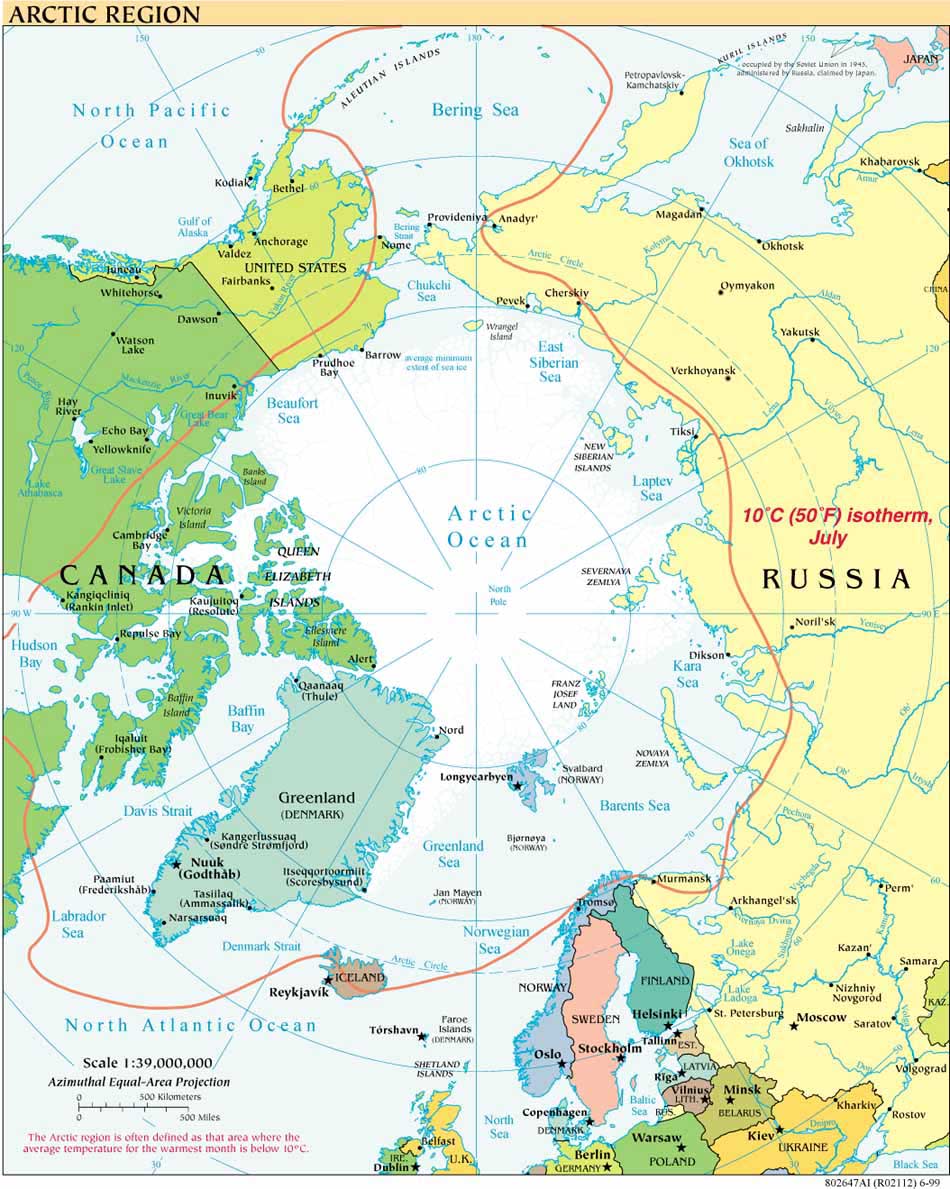
Russia’s two Arctic expeditions met up last week in the Arctic Ocean. According to a report in the RT on the Lomonosov Ridge expedition, published October 9 and revised October 10, “Members of Russia’s North Pole expedition Shelf-2010 have docked with their colleagues on board the Akademik Fyodorov.”  The article provides little more detail, but supplements other statements made about Russian continental shelf mapping at the International Arctic Forum known as the "Territory of Dialogue" held in Moscow September 22-23, 2010. 

As also reported on the website of Denmark's The Continental Shelf Project, one presentation at the Territory of Dialogue Forum was by Christian Marcussen, Senior Adviser, Geological Survey of Denmark and Greenland.  Marcussen is the Project manager for the Greenland part of the Continental Shelf Project of the Kingdom of Denmark.  His presentation, entitled "Extended continental shelf issues in the Arctic Ocean - an example of cooperation between the Arctic coastal states" is available here, at the Dansk Kontinentalsokkelprojektet (which is a standing link on this weblog's right margin).

The "Territory of Dialogue" website provides information related to the September Moscow forum, including the full program, but also offers a range of information about the Arctic, including a newsfeed covering such stories as the Northern Fleet’s role in Arctic cooperation  and Russia’s Antarctic strategy.

A September 2010 article in Hydro-International provides a useful overview of ongoing Russian, Danish, US and Canadian discussions and mapping efforts regarding the Arctic ocean.

Thursday, September 16, 2010

Alaska Arctic Update September 2010: Sea Ice Minimum, Vessel Grounding, Gas, Fish, Exxon Valdez-Deepwater Horizon, Coast Survey Mapping, Broadband

In keeping with this weblog’s two most recent posts, which provide brief updates on recent arctic developments in Canada  and the United States, readers are referred to the September 15, 2010, broadcast and transcript of Alaska News Nightly (produced by the Alaska Public Radio Network) for an Alaska (mostly arctic) update.  Yesterday’s broadcast is a particularly fine edition of this consistently reliable news program and highlights how Alaska faces in microcosm many of the issues facing the Arctic as a whole.

Reports include excellent interviews, both worth hearing in their entirety, about:

-- the Arctic Sea Ice Minimum for 2010, reached September 10, which is the third lowest since satellite data collection began in 1979 (for details visit the National Snow and Ice Data Center  )

-- Tlingit contributions to mapping “Russian America” in the 19th century, providing many of the place names and cartographic features, e.g. from the Lind Canal to Yukon River, that cartographer George Davidson used in his maps for the US Coast Survey. NOAA historian John Cloud was in Klukwan earlier this month to present scanned images of the maps to descendants of the original mappers, the Tlingit leader Kohklux and his wives. The maps are in the public domain, and will soon be posted on this NOAA site; NOAA asks to be credited as the source.

Other stories relate to:
-- Alaska lawyers heading to the Gulf, to bring post-Exxon Valdez experience to litigation resulting from the Deepwater Horizon explosion and spill.
-- a barge running aground about 40 miles west of Prudhoe Bay, although this time equipment failure rather than outdated charts caused the grounding.
-- the proposed All-Alaska Gas Pipeline, as discussed by candidates for governor (see also two different angles on the pipeline here and here).
-- an award-winning commercial seafood processing cooperative plant in Sitka that sends between 50 and 60% of its product overseas.
-- the future of broadband in Alaska, with a focus on public libraries.

Friday, September 3, 2010

Canada Arctic Update August 2010

August 2010 was an active month for Canadian policy developments in the Arctic.  In keeping with this blog’s July 2010 report  on numerous U.S.-related arctic news items for that month, here is a short form update on significant Canadian announcements, projects and decisions in August affecting the Canadian Arctic. 

Prime Minister Stephen Harper used his five day visit to the Arctic, from August 23-27, and the run-up to that visit, to unveil several Canadian initiatives, including the Canadian national policy on the Arctic.

August 20, Ottawa: Canada releases its Arctic Policy, formally titled “Statement on Canada’s Arctic Foreign Policy,” which elaborates on the international component of Canada’s Northern Strategy announced in 2009.

August 26:  Harper announces that his government will establish the Tarium Niryutait Marine Protected Area in the Beaufort Sea, as part of an effort to conserve Beluga whales.  For background on the Tarium Niryutait MPA and on the Beaufort Sea Large Ocean Management Area visit the Beaufort Sea Partnership.

PM Harper’s visit also coincided with:

The August 26th completion of a Canadian Coast Guard training exercise on environmental emergency (oil spill) response in Resolute Bay, Nunavut.

The exercise was part of Canada’s larger annual military training exercise in the North, “Operation NANOOK”.    Danish and US forces participated in the operation for the first time this year. 


Other relevant August 2010 developments for the Canadian Arctic:

August 8; Nunavut judge issues an injunction stopping a science expedition’s seismic operations from the R/V Polarstern in Lancaster Sound.
 
August 25:  Canadian Air Force shadows Russian bombers in international airspace north of Inuvik.

August 29:  Parks Canada announces completion of the 2010 Arctic Survey.

August 30:  The Bahamanian-flagged Clipper Adventurer cruise ship runs aground on uncharted* rocks in the Northwest Passage; Canadian Coast Guard evacuates passengers to Kugluktuk (Update Sept. 8: *subsequent reports indicate that the hazard was known and that the the Canadian Hydrographic Survey had informed the shipping industry of the rock's location in 2007).  Outdated charts appear to have contributed to the August 8 grounding of the fuel resupply vessel the
Mokami near Pangnirtung and the September 2 grounding of the fuel tanker Nanny (Canadian flagged) on a sandbar in Simpson Strait; neither vessel suffered any reported loss of its cargo (the latter ship carried 9.5 million liters of diesel fuel).

Thanks to the Institute of the North  and its Top of the World Telegraph , and to the U.S. Arctic Research Commission Arctic Update for reporting earlier on many of the sources drawn on here.

Tuesday, July 27, 2010

U.S. Arctic and Oceans Update July 2010

July was a busy month in the United States for Arctic and oceans related matters.  Herewith, a tweet-like survey of some highlights, from back to front:

July 26:  
Final preparations are underway for this year’s continuation of US mapping efforts on the Arctic extended continental shelf (ECS). The 2010 ECS Project mapping cruise, for which the US Geological Survey is the science lead, is scheduled from August 2 - September 6, 2010, on the USCGC Healy.  The Healy will travel in tandem again this year with the Canadian Coast Guard icebreaker the  Louis S. St.-Laurent for part of the cruise, as reported in the USGS press release

July 22:  US and Canadian officials met quietly in Ottawa to discuss resolving the maritime boundary dispute in the Beaufort Sea.   For background and a map, see this earlier post.

July 22:  President Obama assigned responsibility for Arctic research to the White House National Science and Technology Council (NSTC), which will coordinate activities assigned to the Interagency Arctic Research and Policy Committee (IARPC).  IARPC and the US Arctic Research Commission (USARC) were created by the 1984 Arctic Research and Policy Act and consult on arctic policy and planning.  The press release is on the USARC website, where the USARC biennial "Report on Goals and Objectives for Arctic Research is also available.

July 19:  President Obama issued an Executive Order  establishing a National Policy for the Stewardship of the Ocean, Coasts, and Great Lakes.  The Order largely adopts the  Final Recommendations of the Interagency Ocean Policy Task Force.  Among the many steps the order announces, it “provides for the development of coastal and marine spatial plans that build upon and improve existing Federal, State, tribal, local, and regional decisionmaking and planning processes."  A related posting is available here. 

July 16:  Eighty-six days after the April 20, 2010, explosion of the Deepwater Horizon rig at the BP Macondo well in the Gulf of Mexico, oil flowing from the well was, at last, temporarily halted by a capping stack system.  The cap continues to hold while efforts continue to close the well permanently.  More information is at the official site of the government oil spill response effort.

July 15: The Interagency and Science Advisory Committees of the Submarine Arctic Science Cruises Program (the SCience ICe EXerices (SCICEX) Program) published a new science plan for the Arctic Ocean, drawing on the potential of the U.S. Navy’s nuclear-powered submarines for data collection. The plan under “Part 1: Technical Guidance for Planning Science Accommodations Missions,” is available under publications at the USARC website.


July 14:   The House passed HR 2864, a bill that, if approved by the Senate and signed into law, would require NOAA to increase its mapping efforts in the Arctic.  See the NOAA Office of Legislative Affairs.  The bill was introduced by Rep. Don Young of Alaska.  The Arctic Marine Shipping Assessment approved by the Ministerial meeting of the Arctic Council in 2009 provides a good overview of the need for improved mapping of the Arctic Ocean for navigational and other purposes.


Icebreaking into the Arctic

The USCGC HEALY embarked Barrow, Alaska, in August 2008 to map the US extended continental shelf, or ECS, in the Arctic Ocean (HLY 0805). Healy sailed again from 7 August to 16 September, 2009 (HLY 0905) to continue ECS mapping, joining with the Canadian icebreaker, the Louis S. St.-Laurent. The two vessels mapped together again in 2010 (see HLY1002) and 2011 (HLY1102).

As the only law professor on the science crew, I was along on HLY 0805 and 0905 to better understand
the science behind the legal process that the UN Convention on the Law of the Sea establishes for states making ECS submissions. As to why the US is mapping now, even though it has not yet acceded to the Convention, read on both here, and in the Law of the Sea notes below.

Thanks to
Vermont Law School and especially to Larry Mayer, Director of the University of New Hampshire's Center for Coastal and Ocean Mapping, for making my part in the trip possible.
Thanks, as well, to Adriane Colburn, for opening new windows on and for the deep.